ViewTube

ViewTube
Sign inSign upSubscriptions
Filters

Upload date

Type

Duration

Sort by

Features

Reset

56 results

Native GIS
This AI Understands Your Maps Better Than You Do 😱

That's exactly what a GIS Co-Pilot does—bringing AI-powered spatial analysis to life. In this Short, we break down what a GIS ...

0:39
This AI Understands Your Maps Better Than You Do 😱

0 views

18 hours ago

Milos Makes Maps
This Free Technique Makes 3D Maps Look Cinema-Quality

Stop scrolling! Dive into this captivating video that reveals how to craft a stunning publication-quality 3D map of Italy using raw ...

18:36
This Free Technique Makes 3D Maps Look Cinema-Quality

439 views

1 day ago

PardesLine
09 - Stereo Vision 3D Reconstruction Tutorial | Python OpenCV Open3D Complete Pipeline

Learn how to create stunning 3D point clouds from stereo camera images using Python, OpenCV, and Open3D!

4:35
09 - Stereo Vision 3D Reconstruction Tutorial | Python OpenCV Open3D Complete Pipeline

104 views

6 days ago

Geospatial Technology & Data Science
ESDA with PySAL 2025 12 26 08 56 52

I sincerely apologize to all my subscribers for my long absence. I posted my last video in November of 2024. The year 2025 has ...

1:15:25
ESDA with PySAL 2025 12 26 08 56 52

13 views

6 days ago

Terra Spatial
Creating River Timelapse Animation Using Landsat-8 Imagery in GEE Python | Google Colab

In this tutorial, you'll learn how to create a stunning river course change timelapse animation using Landsat-8 imagery and Google ...

37:59
Creating River Timelapse Animation Using Landsat-8 Imagery in GEE Python | Google Colab

508 views

4 days ago

Geojay GIS Solution
Merge Features Easily In ArcGIS Pro

ArcGISPro #GISTips #DataManagement #FeatureMerge #GeospatialAnalysis Buy me a coffee here: ...

0:11
Merge Features Easily In ArcGIS Pro

0 views

20 hours ago

Geojay GIS Solution
Step by step guide on Corine Land Cover tutorial

LandUseLandCover #GEE #RemoteSensing #GeospatialAnalysis #GISTutorial Buy me a coffee here: ...

0:14
Step by step guide on Corine Land Cover tutorial

116 views

5 days ago

Sir Kwofae
Find the Line Density Tool in ArcGIS: Quick Guide. #gis #arcgis #gistutorial

In preparation of Drainage Density Map in ArcGIS, you need the line Density Tool of the ArcToolbox to do that. This short focuses ...

0:13
Find the Line Density Tool in ArcGIS: Quick Guide. #gis #arcgis #gistutorial

242 views

6 days ago

Geojay GIS Solution
How To Merge Features In ArcGIS Pro For You

ArcGISPro #GISTips #DataManagement #FeatureMerge #GeospatialAnalysis Buy me a coffee here: ...

0:12
How To Merge Features In ArcGIS Pro For You

0 views

3 days ago

Geojay GIS Solution
GEE Land Use Land Cover Classification Tutorial

LandUseLandCover #GEE #RemoteSensing #GeospatialAnalysis #GISTutorial Buy me a coffee here: ...

0:19
GEE Land Use Land Cover Classification Tutorial

104 views

5 days ago

Code With Yasir Nawaz
DBSCAN Clustering in Python | Non-Linear Data & Outlier Detection

Description In this video, we explore DBSCAN (Density-Based Spatial Clustering of Applications with Noise), a powerful clustering ...

1:00:48
DBSCAN Clustering in Python | Non-Linear Data & Outlier Detection

0 views

4 days ago

Rado Yendra
PRAKTIKUM, KODING PYTHON UNTUK SPATIAL ANALYSIS ORDINARY KRIGING DATA HUJAN PULAU SUMATRA

PEMETAAN HUJAN MENGGUNAKAN KODING PYTHON UNTUK DATA HUJAN DI PULAU SUMATRA SANGAT PENTING ...

10:45
PRAKTIKUM, KODING PYTHON UNTUK SPATIAL ANALYSIS ORDINARY KRIGING DATA HUJAN PULAU SUMATRA

0 views

59 minutes ago

SMILE 😊
MINOR 1 PROJECT

In this video, I present my project on City Road Traffic Density Analysis. We explore how data science can help identify congestion ...

12:04
MINOR 1 PROJECT

0 views

5 days ago

Rado Yendra
PRAKTIKUM, KODING PYHTON UNTUK KAJIAN SPATIAL ANALISIS DENGAN ORDINARY KRIGING UNTUK RATA RATA HUJAN

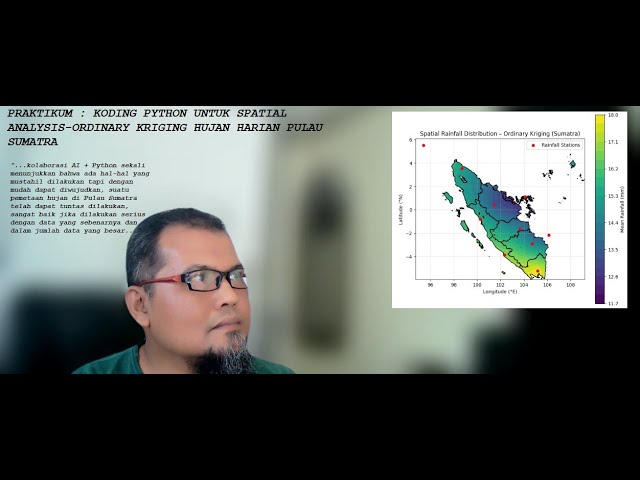
KODING PYTHON UNTUK SPATIAL ANALYSIS - ORDINARY KRIGING MENGGUNAKAN DATA HUJAN HARIAN PROVINSI ...

9:11
PRAKTIKUM, KODING PYHTON UNTUK KAJIAN SPATIAL ANALISIS DENGAN ORDINARY KRIGING UNTUK RATA RATA HUJAN

0 views

1 hour ago

Full Time GIS
Happy New Year 2026 🌍 | Let’s Map the Future | Full Time GIS #googleearth #googlemaps #map

As we step into a new year, Full Time GIS wishes you success, growth, and powerful mapping ahead. This year, we'll continue ...

0:56
Happy New Year 2026 🌍 | Let’s Map the Future | Full Time GIS #googleearth #googlemaps #map

141 views

2 days ago

Geojay GIS Solution
How To Merge Features in ArcGIS Pro

ArcGISPro #GISTips #DataManagement #FeatureMerge #GeospatialAnalysis Buy me a coffee here: ...

0:31
How To Merge Features in ArcGIS Pro

618 views

1 day ago

CEO ACADEMY
🔴 Curso en vivo | Google Earth Engine

Curso en vivo | Google Earth Engine – Análisis Espacial y Teledetección Aplicada a Recursos Hídricos y Cobertura de Suelo ...

0:32
🔴 Curso en vivo | Google Earth Engine

0 views

6 days ago

Geojay GIS Solution
Land Use Land Cover Classification Tutorial in GEE

LandUseLandCover #GEE #RemoteSensing #GeospatialAnalysis #GISTutorial Buy me a coffee here: ...

1:07
Land Use Land Cover Classification Tutorial in GEE

0 views

5 hours ago

Monkey Manhwa Recap
I Paid $1 for a 'Trash' Game Ring... It Granted Me a [HIDDEN CLASS] and God-Tier Start!

I Paid $1 for a 'Trash' Game Ring... It Granted Me a [HIDDEN CLASS] and God-Tier Start! #animerecap #manhwaedit #anime ...

35:23:59
I Paid $1 for a 'Trash' Game Ring... It Granted Me a [HIDDEN CLASS] and God-Tier Start!

8,343 views

3 days ago

CEO ACADEMY
🔴 Curso en vivo | Google Earth Engine

Curso en vivo | Google Earth Engine – Análisis Espacial y Teledetección Aplicada a Recursos Hídricos y Cobertura de Suelo ...

0:29
🔴 Curso en vivo | Google Earth Engine

50 views

6 days ago