ViewTube

ViewTube
Sign inSign upSubscriptions
Filters

Upload date

Type

Duration

Sort by

Features

Reset

176 results

FOSS4G SotM Oceania
FOSS4G 2025 | Stop Baking the Same Cake: Instant Spatial Data Reporting with Open Source and AI

Reporting on spatial data shouldn't require you to ""bake the same cake"" repeatedly. I spent years collecting and processing ...

4:24
FOSS4G 2025 | Stop Baking the Same Cake: Instant Spatial Data Reporting with Open Source and AI

18 views

11 days ago

Surveying Solutions
Getting Started with Python for GIS | Coordinates, Data Structures, and Distance Calculation

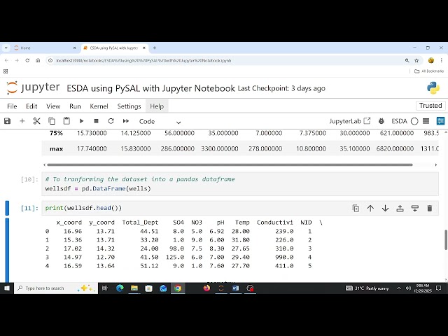
Getting Started with Python for GIS | Coordinates, Data Structures, and Distance Calculation This beginner-friendly guide ...

6:07
Getting Started with Python for GIS | Coordinates, Data Structures, and Distance Calculation

125 views

2 weeks ago

SciData Math
Sesión 03 Geo_Est_25

Vimos el procesamiento de datos de incidencia delictiva para contar con información a nivel estatal para posteriormente unirlos a ...

2:00:43
Sesión 03 Geo_Est_25

245 views

2 weeks ago

MikeIvisonGIS
Ep 4: Code a Day - GIS Programming - String Operations

... making it ideal for students, researchers, professionals, and self-learners interested in mastering spatial data programming."

52:15
Ep 4: Code a Day - GIS Programming - String Operations

0 views

4 weeks ago

Python Scotland
People, Maps and Llamas: using Python at EDINA and the UK Data Service

In this talk, James Crone will take you on a journey through the world of geospatial data processing using Python — from ...

37:32
People, Maps and Llamas: using Python at EDINA and the UK Data Service

11 views

Streamed 4 weeks ago

Terra Spatial
Estimate Surface Water Temperature Using Landsat Series Imagery in GEE Python Colab

In this video, you'll learn how to estimate Surface Water Temperature (SWT) using Landsat-8 and Landsat-9 thermal imagery with ...

44:48
Estimate Surface Water Temperature Using Landsat Series Imagery in GEE Python Colab

487 views

2 weeks ago

Matt Forrest
Everything Is Changing in Geospatial, Here’s What Actually Matters

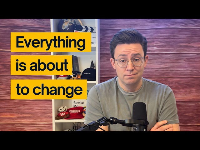
If there's one word to describe the past year in geospatial, it's change. In this solo episode, I take you behind the scenes of what ...

25:55
Everything Is Changing in Geospatial, Here’s What Actually Matters

2,257 views

2 weeks ago

PyData
Annemarijn Blom - Identifying playstyles in football through spatial networks -PyData Eindhoven 2025

Annemarijn Blom - Identifying playstyles in football through spatial networks - PyData Eindhoven 2025 - PySport track ...

32:04
Annemarijn Blom - Identifying playstyles in football through spatial networks -PyData Eindhoven 2025

169 views

2 weeks ago

Roffatech Solutions
Project Imbed Part 2 - Creating Map Coordinates to Be Used As Sample Data For a Heatmap Later

This video shows one way to generate a list of coordinates to provide sample data for a heatmap of mattress-tag-pulling incidents.

2:25
Project Imbed Part 2 - Creating Map Coordinates to Be Used As Sample Data For a Heatmap Later

2 views

8 days ago

Native GIS
This AI Understands Your Maps Better Than You Do 😱

That's exactly what a GIS Co-Pilot does—bringing AI-powered spatial analysis to life. In this Short, we break down what a GIS ...

0:39
This AI Understands Your Maps Better Than You Do 😱

0 views

18 hours ago

Matt Forrest
Desktop GIS Is Slowing You Down. GeoPandas Isn't.

GeoPandas is one of the most important tools in modern GIS, but many people still aren't sure when to use it, why it matters, ...

15:55
Desktop GIS Is Slowing You Down. GeoPandas Isn't.

1,522 views

3 weeks ago

Seneng Jalan
GEOAI - Urban AI: The Advanced Urban Analysis App — From Maps to Reports Automatically!

Urban AI is a powerful GIS web application built with a modern technical stack—FastAPI for high-performance backend ...

2:24
GEOAI - Urban AI: The Advanced Urban Analysis App — From Maps to Reports Automatically!

45 views

3 weeks ago

Pratik Chaudhari
Spatial Data Tutorial Implementation
14:47
Spatial Data Tutorial Implementation

11 views

3 weeks ago

Geospatial Technology & Data Science
ESDA with PySAL 2025 12 26 08 56 52

I sincerely apologize to all my subscribers for my long absence. I posted my last video in November of 2024. The year 2025 has ...

1:15:25
ESDA with PySAL 2025 12 26 08 56 52

13 views

6 days ago

MikeIvisonGIS
Ep 5a: Code a Day - GIS Programming - Loops and Conditions

... making it ideal for students, researchers, professionals, and self-learners interested in mastering spatial data programming."

38:44
Ep 5a: Code a Day - GIS Programming - Loops and Conditions

15 views

4 weeks ago

PardesLine
09 - Stereo Vision 3D Reconstruction Tutorial | Python OpenCV Open3D Complete Pipeline

Learn how to create stunning 3D point clouds from stereo camera images using Python, OpenCV, and Open3D!

4:35
09 - Stereo Vision 3D Reconstruction Tutorial | Python OpenCV Open3D Complete Pipeline

104 views

6 days ago

Milan's Data Stories
30 Days, 30 Maps - My Full #30DayMapChallenge 2025 Tool Summary

In this video, I wrap up my #30DayMapChallenge journey by showcasing all 50 Python libraries I used to create 30 maps in 30 ...

8:10
30 Days, 30 Maps - My Full #30DayMapChallenge 2025 Tool Summary

87 views

1 month ago

MikeIvisonGIS
Ep 5b: Code a Day - GIS Programming - Loops and Conditions

... making it ideal for students, researchers, professionals, and self-learners interested in mastering spatial data programming."

52:01
Ep 5b: Code a Day - GIS Programming - Loops and Conditions

0 views

4 weeks ago

PyData
Gabriel Masella - xReceiver: a GNN approach to the evaluation of... - PyData Eindhoven 2025

Gabriel Masella - xReceiver: a GNN approach to the evaluation of the decision-making process of passing options in football ...

25:16
Gabriel Masella - xReceiver: a GNN approach to the evaluation of... - PyData Eindhoven 2025

94 views

2 weeks ago

The Lone Crater
How to Use Geopandas in Jupyter Notebook - Step by Step

Geopandas, Jupyter Notebook, Spatial Analysis, Python Libraries for Geospatial Data, Mapping with Python, #GeoAnalysis, ...

1:50
How to Use Geopandas in Jupyter Notebook - Step by Step

0 views

3 weeks ago