Upload date
All time
Last hour
Today
This week
This month
This year
Type
All
Video
Channel
Playlist
Movie
Duration
Short (< 4 minutes)
Medium (4-20 minutes)
Long (> 20 minutes)
Sort by
Relevance
Rating
View count
Features
HD
Subtitles/CC
Creative Commons
3D
Live
4K
360°
VR180
HDR
159,072 results
Ready to move beyond desktop GIS? Step into the Spatial Lab: a global community for ambitious geospatial professionals who ...
12,416 views
10 months ago
Learn about Geospatial Analysis with the National Student Data Corps! What is geospatial data and why is it so important?
900 views
1 year ago
Clive started out with BGS as a cartographer creating geological maps of the country. Today, he works as a Geospatial data ...
4,082 views
2 years ago
Rapid advancements in geospatial technologies such as geographical information systems (GIS), global position systems (GPS) ...
23,190 views
3 years ago
68,580 views
This video introduces concepts around geospatial analysis. It is a part of the geospatial analytics with Kinetica series. Kinetica is a ...
10,826 views
4 years ago
Learn what spatial analysis means in GIS and mapping. Discover how geographic data, remote sensing, and spatial relationships ...
11,124 views
Recorded lecture by Luc Anselin at the University of Chicago (Fall 2020).
59,477 views
Learn about Geospatial Analysis with the National Student Data Corps! How does geospatial data allow us to learn from the world ...
260 views
Looking to dive into geospatial data analysis using Python? This comprehensive Geopandas tutorial is perfect for you! Whether ...
67,931 views
To know more on Geo-spatial technology, Refer Weekly Focus 76: Geo-spatial data and National Security. Download at: ...
18,429 views
25,154 views
Interested in spatial data science but not sure how to get started? In this video, I discuss what spatial data science is and how you ...
28,908 views
Snowflake provides for seamless handling of geospatial data, making it easier to work with location-based information directly in ...
1,742 views
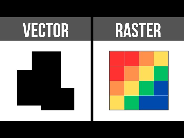
In the subject of Geographic Information Systems (GIS), the vector and raster formats are two ways of representing real-world ...
32,439 views
Sherrie Xie, Post-doctoral research fellow at the University of Pennsylvania gave a workshop at the R/Medicine 2022 Virtual ...
13,384 views
Learn more: https://spatialelearning.com Get the full course: ...
80,101 views
We'll go through some high-level examples of various kinds of geospatial analysis, at scale. We'll see how the tools developed by ...
775 views
What is GIS? https://gisgeography.com/what-is-gis/ GIS stands for Geographic Information Systems. It's a computer-based tool that ...
252,893 views
174,629 views