Upload date
All time
Last hour
Today
This week
This month
This year
Type
All
Video
Channel
Playlist
Movie
Duration
Short (< 4 minutes)
Medium (4-20 minutes)
Long (> 20 minutes)
Sort by
Relevance
Rating
View count
Features
HD
Subtitles/CC
Creative Commons
3D
Live
4K
360°
VR180
HDR
5,113 results
Master spatial data in Python! In this 60-second quickstart, Taisin shows you how to install casaGeoTools, set up secure ...
0 views
4 days ago
... Data is Critical Infrastructure 00:09:20 – Demystifying Census Data with tigris and tidycensus 00:15:48 – Applied Spatial Data: ...
824 views
3 days ago
Resources & Further Learning - Practice notebook → https://go.visuallyexplained.co/file-handling-exercises - Practice ...
12,026 views
Start building real Python skills today with DataCamp's Python Programming Fundamentals track (perfect if you're still shaky on ...
27,963 views
Subscribe and Support the channel for more Free content https://www.youtube.com/ @DataWithBaraa ━━━━━ *MY ...
4,696 views
1 day ago
School of Programming and Software Development sop-AI-101: Python for Data Science This lesson introduces us to Exploratory ...
6 views
2 days ago
In Part 3 of this Data Visualization with Python Course 2026, you will create categorical, advanced statistical, and geospatial ...
57 views
Masters In Data-Analytics with GenAI with Job Guarantee Program - https://codingwise.in/program/data-analytics Python for ...
33,870 views
IIRS-ISRO.
2,684 views
Streamed 3 days ago
OXYLABS WEB SCRAPER API* Scrape up to 2K results for free: https://oxy.yt/jcW1 Python web scraping is a crucial skill for ...
379 views
14 hours ago
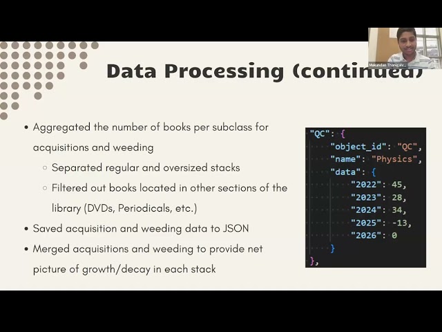
by Corinne Chatnik and Mukundan Thanigaivelan (Union College) As library collections evolve, understanding spatial growth ...
Spatial AI Scientist is redefining how artificial intelligence works with geography, spatial data, and real-world systems. In this video ...
Full Course https://www.youtube.com/playlist?list=PLWlgkWEhTvz0oqrq6PP6ZbkMqCLXXMNsT Learn how to *add polyline ...
3 views
20 hours ago
Full Course https://www.youtube.com/playlist?list=PLWlgkWEhTvz0oqrq6PP6ZbkMqCLXXMNsT Learn how to *add point ...
7 views
In this video, I showcase my latest computer vision project: Advanced Vision-Based ADAS with Real-Time Schematic Mapping.
85 views
📌 About This Video 👉 Is Python the Coding Language of the Future | Python Programming | Python Tutorial PDF Link :- https ...
“Calculate coverage area of point layer” → Quick spatial analysis without manual geoprocessing steps. 4. “Calculate average ...
12 hours ago
In this video, you'll learn the fastest and easiest method to create a powerful Wind Rose Diagram using Python in Google Colab, ...
285 views
DBSCAN (Density-Based Spatial Clustering of Applications with Noise) is an unsupervised machine learning algorithm used to ...
493 views
6 days ago
Spatial Analysis: "Calculate the total area of parks in this district" or "Find all bus stops within 500m of the metro station.


![Data Visualization with Python Course [2026] - Part 3: Categorical, Statistical & Geospatial Charts](/api/proxy/image?url=https%3A%2F%2Fi.ytimg.com%2Fvi%2FR4mnsA5dctU%2Fsddefault.jpg)