ViewTube

ViewTube
Sign inSign upSubscriptions
Filters

Upload date

Type

Duration

Sort by

Features

Reset

267 results

Medicine RTCL TV
SDMtoolbox 2.0: the next generation Python-based GIS toolkit for landscape genetic, b... | RTCL.TV

Keywords ### #Geographicinformationsystems #MaxEntbiasfiles #ArcGIS #Ecologicalnichemodels #Spatialjackknifing ...

0:25
SDMtoolbox 2.0: the next generation Python-based GIS toolkit for landscape genetic, b... | RTCL.TV

23 views

1 year ago

R Consortium
useR! 2020: Spatial data handling and visualization (S. Rochette, D. Scott, J. Nowosad), tutorial

This video is part of the virtual useR! 2020 conference. Find supplementary material on our website https://user2020.r-project.org/ ...

1:56:10
useR! 2020: Spatial data handling and visualization (S. Rochette, D. Scott, J. Nowosad), tutorial

1,360 views

5 years ago

Medicine RTCL TV
SDMtoolbox 2.0: the next generation Python-based GIS toolkit for landscape genetic, b... | RTCL.TV

Keywords ### #Geographicinformationsystems #MaxEntbiasfiles #ArcGIS #Ecologicalnichemodels #Spatialjackknifing ...

0:28
SDMtoolbox 2.0: the next generation Python-based GIS toolkit for landscape genetic, b... | RTCL.TV

21 views

1 year ago

R Consortium
Keynote: R Spatial

Pebesma, Edzer R Spatial is a lively community of people using R for analysing spatial data. From the early days of R, spatial ...

56:10
Keynote: R Spatial

2,047 views

4 years ago

NPTEL IIT Bombay
Tutorial 10: Processing Satellite Precipitation Data Using Python

Week 11: Tutorial 10: Processing Satellite Precipitation Data Using Python.

43:53
Tutorial 10: Processing Satellite Precipitation Data Using Python

1,837 views

3 years ago

wikipedia tts
Spatial analysis | Wikipedia audio article

This is an audio version of the Wikipedia Article: https://en.wikipedia.org/wiki/Spatial_analysis 00:01:22 1 History 00:03:12 2 ...

47:59
Spatial analysis | Wikipedia audio article

45 views

6 years ago

BetaNYC
28 Spatial Analysis of NYC Open Data using ArcGIS

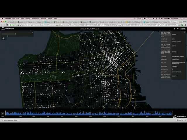
NYC School of Data 2024 - March 23, 2024 28 Spatial Analysis of NYC Open Data using ArcGIS Jim Barry - Solution Engineer, ...

59:16
28 Spatial Analysis of NYC Open Data using ArcGIS

233 views

1 year ago

Geo BTAA
Python and ArcGIS Notebooks Improve Reproducibility of County Health Indicator

Jess Hoffelder and Ganhua Lu, University of Wisconsin Madison Population Health Institute Access to exercise opportunities is a ...

16:22
Python and ArcGIS Notebooks Improve Reproducibility of County Health Indicator

76 views

2 years ago

IHE Delft - Water Accounting
[WAPOROCW] M2-2.0 WAPORWP protocol Python

In this video lecture, you will be guided on how you can use the protocol (the Jupyter Notebook in Python protocol) to analyze ...

15:00
[WAPOROCW] M2-2.0 WAPORWP protocol Python

1,001 views

5 years ago

Dutton Institute
GEOG 489 Advanced Python programing for GIS

Geospatial Education at Penn State. For more information go to www.pennstategis.com or https://gis.e-education.psu.edu/

1:36
GEOG 489 Advanced Python programing for GIS

1,424 views

7 years ago

Berkeley Institute for Data Science (BIDS)
Big Data Mapping: Modern Tools for Geographic Analysis and Visualization

BIDS Data Science Lecture Series | February 13, 2015 | 1:00-2:30 p.m. | 190 Doe Library, UC Berkeley Speaker: Erez Cohen, ...

1:01:54
Big Data Mapping: Modern Tools for Geographic Analysis and Visualization

13,369 views

Streamed 11 years ago

Dutton Institute
Geography 581, Spatial Data Science Ethics

Geospatial Education at Penn State. For more information go to www.pennstategis.com or https://gis.e-education.psu.edu/

2:41
Geography 581, Spatial Data Science Ethics

296 views

3 years ago

STEM RTCL TV
Geostatistical interpolation of daily rainfall at catchment scale: the use of several... | RTCL.TV

Keywords ### #dailyrainfall #rainfallinterpolation #researchcompared #ExternalDrift #deterministicmethods #OrdinaryKriging ...

0:36
Geostatistical interpolation of daily rainfall at catchment scale: the use of several... | RTCL.TV

208 views

2 years ago

NYC Open Data Week
Mapping open school and census data in New York City

NYC Open Data Week 2024 98 Mapping open school and census data in New York City - March 19 2024 Matthew Curinga ...

33:30
Mapping open school and census data in New York City

43 views

1 year ago

STEM RTCL TV
Semantic typing of linked geoprocessing workflows | RTCL.TV

Keywords ### #geoprocessing #spatialanalysis #workflows #semantictyping #linkeddata #RTCLTV #shorts ### Article Attribution ...

0:53
Semantic typing of linked geoprocessing workflows | RTCL.TV

2 views

2 years ago

ResearchData UoE
MANTRA - Ellie Bates - Challenges in working with spatial data

This video is part of MANTRA, the Research Data Management free online course created by the University of Edinburgh Data ...

5:34
MANTRA - Ellie Bates - Challenges in working with spatial data

5,251 views

12 years ago

Dutton Institute
Feature Extraction Basics - LiDAR Imagery

Created by Dr. Jarlath O'Neil-Dunne for GEOG 883 at Penn State Univeristy.

16:52
Feature Extraction Basics - LiDAR Imagery

696 views

6 years ago

weecology
Geospatial Data in R - Aggregating Raster Data Inside of Polygons

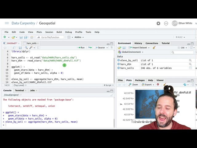
Data: https://datacarpentry.org/semester-biology/data/neon-geospatial-data.zip Written notes: ...

11:03
Geospatial Data in R - Aggregating Raster Data Inside of Polygons

4,925 views

5 years ago

STEM RTCL TV
Tree Species Classification with Random Forest Using Very High Spatial Resolution 8-B... | RTCL.TV

Keywords ### #treespeciesclassification #temperateforest #WorldView2 #RandomForest #lineardiscriminantanalysis ...

0:35
Tree Species Classification with Random Forest Using Very High Spatial Resolution 8-B... | RTCL.TV

148 views

2 years ago

Dutton Institute
GIS Instructor J. B. Sharma Introduces himself to Students at Penn State

J.B. Sharma, PhD, Professor Emeritus at the University of North Georgia, is now teaching Remote Sensing Image Analysis and ...

1:43
GIS Instructor J. B. Sharma Introduces himself to Students at Penn State

420 views

5 years ago