Upload date
All time
Last hour
Today
This week
This month
This year
Type
All
Video
Channel
Playlist
Movie
Duration
Short (< 4 minutes)
Medium (4-20 minutes)
Long (> 20 minutes)
Sort by
Relevance
Rating
View count
Features
HD
Subtitles/CC
Creative Commons
3D
Live
4K
360°
VR180
HDR
827 results
In this comprehensive GIS tutorial, we'll move beyond basic mapping to answer a critical urban planning question: How ...
2,849 views
11 months ago
This video offers a python programming tutorial showing how to use US Census tract-level data to make a thematic map with ...
21 views
7 months ago
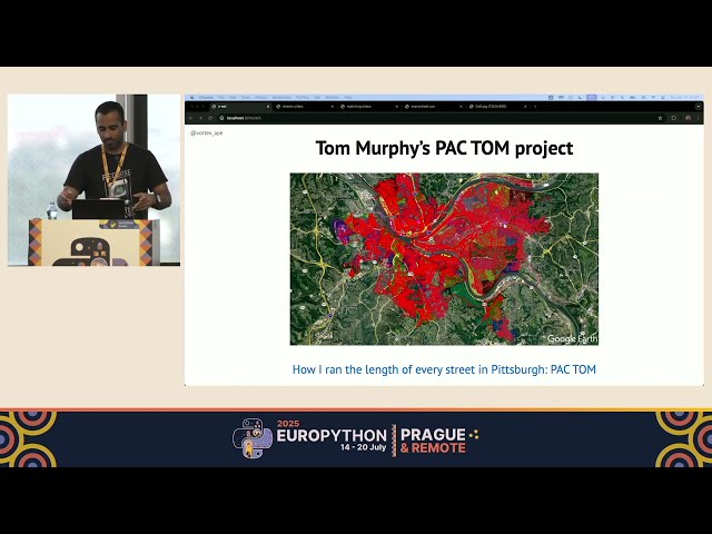
EuroPython 2025 — Terrace 2B on 2025-07-17] *Running every street in Paris with Python and PostGIS by Vinayak Mehta* ...
218 views
This session was recorded live at State of the Map US 2025 in Boston, Massachusetts. Hosted by OpenStreetMap US, the annual ...
43 views
10 months ago
Presented by Alen Mangafić, Tomaž Žagar on 20 November 2025 16:00, at FOSS4G 2025 Auckland. Track: Academic Full ...
72 views
5 months ago
I scraped Wikipedia, geocoded 70+ AI companies, and plotted them on an interactive world map using BeautifulSoup, ...
133 views
1 month ago
By: Luis de Sousa (University of Lisbon) OpenGeoHub Summer School Wageningen 2025 ...
70 views
8 months ago
Presented by Ellorine Carle on 21 November 2025 09:30, at FOSS4G 2025 Auckland. Track: Lightning talk Full presentation ...
33 views
website:- https://www.framenet.ai/?utm_source=yt_map Coupon Code:- EARLY50 ( Apply this code during checkout to get 50% ...
12,901 views
... 3:01 - Naval Invasion by Affa 4:15 - PYTHON Maps! 5:10 - Paint Map XD !! 5:22 - Explaining 6:00 - How to Import Custom Maps.
7,762 views
4 months ago
Python has multiple data types and data structures that you can use to store and manipulate data efficiently. Some of them are ...
19 views
We use the miximaps python helper package to make a nice, interactive map showing median income in NYC and surrounding ...
7 views
In this video, we delve into the intricacies of Python's map object and explore a common issue that many developers encounter: ...
5 views
TOOLS USED IN THIS VIDEO: - iPhone for photo - Python for GPS extraction and Streamlit server - QGIS for visualizing location I ...
27 views
2 months ago
What if you wanted to generate a map image for each authority in the UK? QGIS's built-in Python functionality makes this possible ...
2 days ago
EuroPython 2025 — North Hall on 2025-07-17] *Offline Disaster Relief Coordination with OpenStreetMap and FastAPI by ...
94 views
Here's how to create a realtime map and visualisation of your Kubernetes clusters using the Otterize network mapper and a little ...
342 views
In this video, we dive into the performance differences between Python 3.5 and 3.6, focusing specifically on the 'map' function and ...
3 views
6 months ago
In this video, we'll explore the process of converting a Python dictionary into a Dart map, a crucial skill for developers working with ...
0 views
9 months ago
https://amzn.to/4aLHbLD You're literally one click away from a better setup — grab it now! As an Amazon Associate I earn ...
66 views