ViewTube

ViewTube
Sign inSign upSubscriptions
Filters

Upload date

Type

Duration

Sort by

Features

Reset

382,690 results

Data with Baraa
Python Iterator vs Iterable (Visually Explained) | enumerate, map, filter | #Python Course 31

Visually explained the difference between iterators and iterables in Python using enumerate, map, and filter with simple examples.

23:27
Python Iterator vs Iterable (Visually Explained) | enumerate, map, filter | #Python Course 31

16,055 views

8 months ago

Visually Explained
Python Lambda Functions - Visually Explained

Resources & Further Learning - Practice notebook: https://rebrand.ly/k0ziezz Chapters 00:00 - Intro 00:12 - Syntax 02:40 - Why ...

8:15
Python Lambda Functions - Visually Explained

218,027 views

11 months ago

INFORMATICONFIG
Python course from scratch for beginners | MAP() FUNCTION (video 58)

CONTACT: informaticonfig@gmail.com DONATE: paypal.me/informaticonfig patreon.com/informaticonfig

4:59
Python course from scratch for beginners | MAP() FUNCTION (video 58)

249 views

7 months ago

Code Nust
Python Guide 2026 – How to Learn Python FAST (Complete Beginner Roadmap) | Python Roadmap

Are you frustrated trying to learn Python but can't find the exact roadmap in 2026? Most beginners jump between tutorials, courses ...

4:15
Python Guide 2026 – How to Learn Python FAST (Complete Beginner Roadmap) | Python Roadmap

1,022 views

3 months ago

elephantzdevs
scrappy: Free Google Maps Scraper + CRM Auto-Import with Python, n8n (Free Apify Alternative)

Learn how to build a free Google Maps lead scraper that automatically imports to your CRM using Python, and n8n automation.

9:58
scrappy: Free Google Maps Scraper + CRM Auto-Import with Python, n8n (Free Apify Alternative)

247 views

8 months ago

Milan's Data Stories
Crop Mapping from Sentinel-2 Satellite Imagery — GeoAI with Python

In this free preview from the Fundamentals of GeoAI course, we define our study area over an agricultural region in Hungary to ...

8:23
Crop Mapping from Sentinel-2 Satellite Imagery — GeoAI with Python

914 views

3 months ago

Florent Poux
AI Tutorial to Create 3D Models From ANY Image (3D MapAnything Zero-Shot Workflow with Python)

Get 3D GeoAI System → https://learngeodata.eu/geo-ai-sprint-course Get my Book → https://amzn.to/49d1rW2 ...

22:57
AI Tutorial to Create 3D Models From ANY Image (3D MapAnything Zero-Shot Workflow with Python)

3,886 views

8 months ago

Data with Baraa
Python Lambda Functions (Visually Explained) | #Python Course 32

Visually explained how lambda functions work in Python to write clean, short, and efficient code with practical examples.

15:51
Python Lambda Functions (Visually Explained) | #Python Course 32

20,839 views

8 months ago

BL Codes
Python Tutorial | How to Generate a Procedural Elevation Map from Scratch

Article Version of Tutorial ...

9:19
Python Tutorial | How to Generate a Procedural Elevation Map from Scratch

35 views

8 months ago

Intellipaat
Python Roadmap for Beginners 2026 | From Zero to Job Ready | Intellipaat

Enroll for Intellipaat's Python Course: https://intellipaat.com/python-certification-training-online/ Book your Free ...

5:11
Python Roadmap for Beginners 2026 | From Zero to Job Ready | Intellipaat

3,896 views

3 months ago

Techie Programmer
Complete Python Roadmap 2026-27 | Zero to AI Jobs in 6 Stages 🚀

COMPLETE PYTHON ROADMAP 2026-27 | Your Step-by-Step Guide to Mastering Python Python is evolving faster than ever!

3:46
Complete Python Roadmap 2026-27 | Zero to AI Jobs in 6 Stages 🚀

2,492 views

7 months ago

Milos Makes Maps
Can You Create Stunning Lighthouse Maps with Python in Just 20 Minutes?

Dive into the world of GIS and mapping with this Python tutorial! We'll turn OpenStreetMap data into a mesmerizing animater ...

21:33
Can You Create Stunning Lighthouse Maps with Python in Just 20 Minutes?

1,081 views

7 months ago

Zafar Iqbal
Python - Lecture 17 - Map Filter and Reduce

In this video we explore how Python built-in function map, filter and reduce and how the can be applied in Python programming.

19:52
Python - Lecture 17 - Map Filter and Reduce

3,281 views

5 months ago

Milan's Data Stories
Interactive POI Visualization in Python with OpenStreetMap Data | #30DayMapChallenge 2025 (1/30)

In this video, I provide an overview of how to query spatial data from OpenStreetMap, covering various categories of points of ...

12:03
Interactive POI Visualization in Python with OpenStreetMap Data | #30DayMapChallenge 2025 (1/30)

2,173 views

7 months ago

Milan's Data Stories
This Map Went Viral. I Built It From Scratch in Python

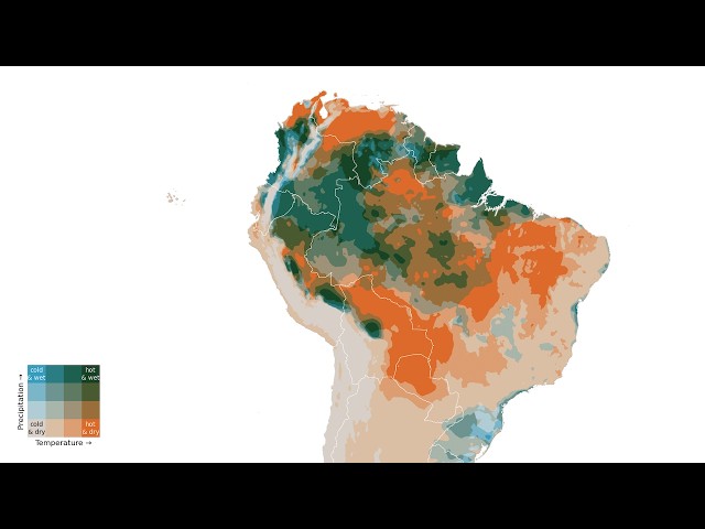
A bivariate map encodes two variables at once using a 2D color scale — every pixel shows both temperature AND precipitation ...

6:26
This Map Went Viral. I Built It From Scratch in Python

3,566 views

3 months ago

Telusko
Map Reduce Function in Python | 37

In this video, we'll learn about ⁠ map() ⁠ and ⁠ reduce() ⁠ in detail — including their syntax, use cases, and best practices.

5:23
Map Reduce Function in Python | 37

8,409 views

7 months ago

Wins with Data
Interactive City Maps in Python: Heatmaps, Routes, and Landmarks with Folium

Build a complete interactive city map in Python with routes, landmarks, and a heatmap using the folium library. This is a simple yet ...

13:16
Interactive City Maps in Python: Heatmaps, Routes, and Landmarks with Folium

717 views

6 months ago

GeoDev
Upload Shapefile to PostgreSQL (PostGIS) with Python & GeoPandas — Full Tutorial

Join this channel to get access to the perks: https://www.youtube.com/channel/UCCV3Wo1EDp--JZTwf0TcFpg/join Learn how to ...

10:34
Upload Shapefile to PostgreSQL (PostGIS) with Python & GeoPandas — Full Tutorial

2,240 views

8 months ago

Tech With Tim
Python programming roadmap - what skills should you learn first

These are two of the best beginner-friendly Python resources I recommend: Python Programming Fundamentals (Datacamp) ...

12:23
Python programming roadmap - what skills should you learn first

117,055 views

10 months ago

Terra Spatial
How to Map Soil Moisture Index Using SMAP Data | GEE Python & Google Colab

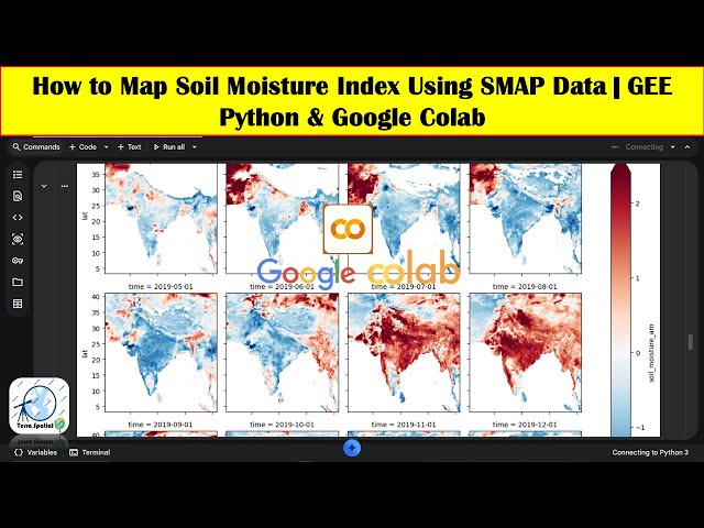
Learn how to compute and map the Standardized Soil Moisture Index (SSI) using NASA SMAP soil moisture data in Google Earth ...

48:58
How to Map Soil Moisture Index Using SMAP Data | GEE Python & Google Colab

1,199 views

5 months ago