ViewTube

ViewTube
Sign inSign upSubscriptions
Filters

Upload date

Type

Duration

Sort by

Features

Reset

66 results

Zbigniew Mikulski
Exporting Data for Clustering, Python, and Spatial Modeling

Take your research to the next level by bridging QuPath with the global ecosystem of bio-image analysis. In this final session of ...

45:24
Exporting Data for Clustering, Python, and Spatial Modeling

84 views

3 weeks ago

Leonardo Collado Torres
[2025-08-08] Intro to GeoPandas for spatial operations

For more information on Nick Eagles, check https://bsky.app/profile/nick-eagles.bsky.social. For more information about the ...

31:12
[2025-08-08] Intro to GeoPandas for spatial operations

28 views

6 months ago

Native GIS
The Ultimate Python GIS Guide to Mapping Urban Green Space

In this comprehensive GIS tutorial, we'll move beyond basic mapping to answer a critical urban planning question: How ...

31:52
The Ultimate Python GIS Guide to Mapping Urban Green Space

2,657 views

8 months ago

FOSS4G SotM Oceania
FOSS4G 2025 | Stop Baking the Same Cake: Instant Spatial Data Reporting with Open Source and AI

Reporting on spatial data shouldn't require you to ""bake the same cake"" repeatedly. I spent years collecting and processing ...

4:24
FOSS4G 2025 | Stop Baking the Same Cake: Instant Spatial Data Reporting with Open Source and AI

46 views

2 months ago

Leonardo Collado Torres
[2025-07-18] Plots in Python with seaborn and plotnine

For more information on Nick Eagles, check https://bsky.app/profile/nick-eagles.bsky.social. For more information about the ...

37:30
[2025-07-18] Plots in Python with seaborn and plotnine

41 views

6 months ago

Bioinformatics DotCa
CBW Introductory Spatial 'Omics: Visium HD '25 | 03: Building your spatial model

Canadian Bioinformatics Workshop series: - Introductory Spatial 'Omics Analysis: Visium HD, Feb. 20-21, 2025 - Building your ...

59:17
CBW Introductory Spatial 'Omics: Visium HD '25 | 03: Building your spatial model

283 views

11 months ago

The Debug Zone
How to Interpolate Station Data Using Kriging in Python: A Step-by-Step Guide

In this video, we will explore the powerful technique of kriging for interpolating station data using Python. Whether you're working ...

1:48
How to Interpolate Station Data Using Kriging in Python: A Step-by-Step Guide

6 views

6 months ago

The Debug Zone
How to Match Data Frames by Shortest Geographic Distance in Python

In this video, we will explore a powerful technique for matching data frames based on geographic proximity using Python.

1:59
How to Match Data Frames by Shortest Geographic Distance in Python

1 view

2 months ago

The Debug Zone
How to Load JSON Data into a GeoDataFrame in Python: A Step-by-Step Guide

In this video, we'll explore the process of loading JSON data into a GeoDataFrame using Python. GeoDataFrames are essential ...

1:53
How to Load JSON Data into a GeoDataFrame in Python: A Step-by-Step Guide

0 views

3 months ago

Dr. Bradley Battista
NBS eHydro Scraper Recap

Overview of the rearchitected scraper classes. The workflow now leverages DuckDB, MinIO, and PostgreSQL using Python as a ...

15:19
NBS eHydro Scraper Recap

32 views

3 months ago

The Debug Zone
Finding S2 Cells in a Circle Using Python S2/S2sphere Library

In this video, we delve into the fascinating world of spatial data analysis using the S2/S2sphere library in Python. We'll explore ...

1:59
Finding S2 Cells in a Circle Using Python S2/S2sphere Library

9 views

9 months ago

Bioinformatics DotCa
CBW Introductory Spatial 'Omics: Visium HD '25 | 04: Gene enquiry and visualization

Canadian Bioinformatics Workshop series: - Introductory Spatial 'Omics Analysis: Visium HD, Feb. 20-21, 2025 - Gene enquiry ...

29:25
CBW Introductory Spatial 'Omics: Visium HD '25 | 04: Gene enquiry and visualization

242 views

11 months ago

Esri Developers
ArcPy: Working with Raster Data | #EsriDevSummit2024

Using real world examples, this session will include an introduction to the Spatial Analyst and Image Analyst ArcPy modules, best ...

1:03:45
ArcPy: Working with Raster Data | #EsriDevSummit2024

456 views

11 months ago

R Consortium
Scaling the r-spatial ecosystem for the modern composable data pipeline

With the introduction of the sf package, R became home to a first-class spatial data frame API. A growing number of R users, ...

52:45
Scaling the r-spatial ecosystem for the modern composable data pipeline

864 views

8 months ago

The Debug Zone
How to Fit Coordinates to Streets Using OSMnx: A Step-by-Step Guide

In this video, we'll explore the powerful capabilities of OSMnx, a Python library that allows you to download and analyze street ...

2:23
How to Fit Coordinates to Streets Using OSMnx: A Step-by-Step Guide

6 views

3 months ago

The Debug Zone
Understanding SciPy's distance_transform_edt Function: A Comprehensive Guide

In this video, we delve into SciPy's powerful `distance_transform_edt` function, a crucial tool for image processing and analysis.

1:32
Understanding SciPy's distance_transform_edt Function: A Comprehensive Guide

27 views

9 months ago

FOSS4G SotM Oceania
FOSS4G 2025 | Evaluating LLMs as Intermediaries for FOSS4G CLI-based Geospatial Analysis

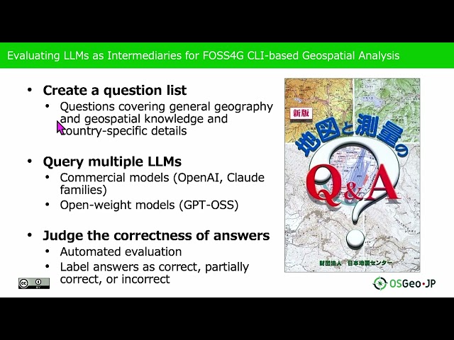
... knowledge and generate appropriate solutions for spatial analysis tasks. The complexity of CLI-based geospatial analysis tools ...

5:12
FOSS4G 2025 | Evaluating LLMs as Intermediaries for FOSS4G CLI-based Geospatial Analysis

56 views

2 months ago

The Debug Zone
How to Retrieve Longitude and Latitude from Node ID Using OSMnx

Join us as we unlock the potential of OSMnx to enhance your mapping and spatial analysis projects! Today's Topic: How to ...

1:32
How to Retrieve Longitude and Latitude from Node ID Using OSMnx

7 views

8 months ago

The Debug Zone
Fastest Way to Plot Coordinates on a Map Inline in Jupyter Notebook

Whether you're a data scientist, a geographer, or just someone interested in visualizing spatial data, this tutorial will guide you ...

1:37
Fastest Way to Plot Coordinates on a Map Inline in Jupyter Notebook

5 views

4 months ago

PythonPH
PyCon APAC 2025 - Moving beyond the spreadsheet by Ben Hur Pintor

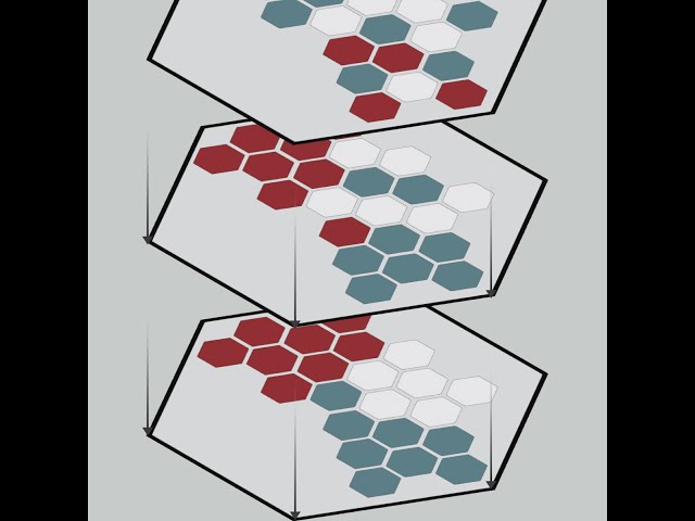
... do um if you're into spatial analytics sports analytics I do mapping of basketball every once in a while you can find me there right ...

26:29
PyCon APAC 2025 - Moving beyond the spreadsheet by Ben Hur Pintor

18 views

9 months ago

FOSS4G SotM Oceania
FOSS4G 2025 | IGEO7 and DGGRID - Like H3, but an Equal-Area Hexagonal DGGS - Fairer Global Analysis

Presented by Alexander Kmoch on 19 November 2025 16:00, at FOSS4G 2025 Auckland. Track: Lightning talk Full presentation ...

2:46
FOSS4G 2025 | IGEO7 and DGGRID - Like H3, but an Equal-Area Hexagonal DGGS - Fairer Global Analysis

31 views

2 months ago

The Debug Zone
Finding Nearest Points in Python: Distance Calculation for Datasets

In this video, we delve into the essential technique of finding the nearest points in datasets using Python. Whether you're working ...

1:56
Finding Nearest Points in Python: Distance Calculation for Datasets

24 views

6 months ago

Esri Chile
Machine Learning and Spatial Prediction: Visualizing Pest Spread in Experience Builder

In this technical session, prepared by Developer David Riquelme from Esri Chile, you will learn how to perform spatial ...

15:16
Machine Learning and Spatial Prediction: Visualizing Pest Spread in Experience Builder

129 views

3 months ago

FOSS4G SotM Oceania
FOSS4G 2025 | Participatory GIS Methods for Urban Redevelopment

Presented by Uyanga Ankhbayar on 20 November 2025 14:00, at FOSS4G 2025 Auckland. Track: Community, Collaboration ...

12:24
FOSS4G 2025 | Participatory GIS Methods for Urban Redevelopment

10 views

2 months ago

FOSS4G SotM Oceania
FOSS4G 2025 | A Scalable Open-Source System for Impervious Land Mapping Using GRASS and Python

Accurate and efficient mapping of these changes is essential in environmental monitoring and spatial analysis. While many tools ...

23:47
FOSS4G 2025 | A Scalable Open-Source System for Impervious Land Mapping Using GRASS and Python

55 views

2 months ago