Upload date
All time
Last hour
Today
This week
This month
This year
Type
All
Video
Channel
Playlist
Movie
Duration
Short (< 4 minutes)
Medium (4-20 minutes)
Long (> 20 minutes)
Sort by
Relevance
Rating
View count
Features
HD
Subtitles/CC
Creative Commons
3D
Live
4K
360°
VR180
HDR
79 results
Monday, Feb 02, 2026 10:00 am - 12:00 pm Presenter: Ryan Horne Networks are everywhere, moving through digital and ...
213 views
4 months ago
For more information on Nick Eagles, check https://bsky.app/profile/nick-eagles.bsky.social. For more information about the ...
31 views
10 months ago
Take your research to the next level by bridging QuPath with the global ecosystem of bio-image analysis. In this final session of ...
219 views
5 months ago
Speaker: Utku Can Ozturk, Data Scientist and main developer of the Gigaspatial project Geospatial data is critical for global ...
14 views
1 month ago
In this technical session, prepared by Developer David Riquelme from Esri Chile, you will learn how to perform spatial ...
139 views
8 months ago
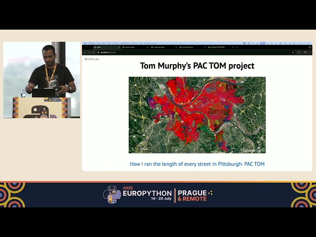
EuroPython 2025 — Terrace 2B on 2025-07-17] *Running every street in Paris with Python and PostGIS by Vinayak Mehta* ...
227 views
Reporting on spatial data shouldn't require you to ""bake the same cake"" repeatedly. I spent years collecting and processing ...
57 views
6 months ago
Accurate and efficient mapping of these changes is essential in environmental monitoring and spatial analysis. While many tools ...
75 views
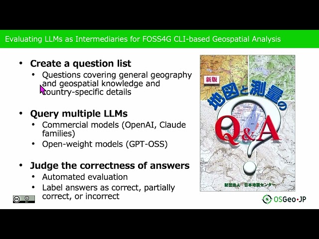
... knowledge and generate appropriate solutions for spatial analysis tasks. The complexity of CLI-based geospatial analysis tools ...
78 views
68 views
Presented by Ellorine Carle on 21 November 2025 09:30, at FOSS4G 2025 Auckland. Track: Lightning talk Full presentation ...
35 views
Presented by Alen Mangafić, Tomaž Žagar on 21 November 2025 09:00, at FOSS4G 2025 Auckland. Track: Academic Full ...
42 views
Overview of the rearchitected scraper classes. The workflow now leverages DuckDB, MinIO, and PostgreSQL using Python as a ...
34 views
In this video, we'll explore the process of loading JSON data into a GeoDataFrame using Python. GeoDataFrames are essential ...
0 views
7 months ago
In this video, we will explore a powerful technique for matching data frames based on geographic proximity using Python.
1 view
Presented by Uyanga Ankhbayar on 20 November 2025 14:00, at FOSS4G 2025 Auckland. Track: Community, Collaboration ...
20 views
Join us for a deep dive into EEG data science, transforming raw, messy electrical signals from the human brain into stunning, ...
499 views
Presented by Joseph Percival on 20 November 2025 11:00, at FOSS4G 2025 Auckland. Track: Tools, Libraries & Visualisation ...
47 views
... OpenSearch, OAI-PMH, SRU), providing a standards-based metadata and catalogue component of spatial data infrastructures.
30 views
Presented by Alexander Kmoch on 19 November 2025 13:30, at FOSS4G 2025 Auckland. Track: Academic Full presentation ...
26 views

![[2025-08-08] Intro to GeoPandas for spatial operations](/api/proxy/image?url=https%3A%2F%2Fi.ytimg.com%2Fvi%2FmXMcPmLUuu8%2Fsddefault.jpg)

![[Barcelona Free Software] Connecting the World: Scalable Geospatial Pipelines with GigaSpatial](/api/proxy/image?url=https%3A%2F%2Fi.ytimg.com%2Fvi%2Fa837wAjBL64%2Fsddefault.jpg)


![[2025-07-18] Plots in Python with seaborn and plotnine](/api/proxy/image?url=https%3A%2F%2Fi.ytimg.com%2Fvi%2FxK9UNcOfjnI%2Fsddefault.jpg)


