Upload date
All time
Last hour
Today
This week
This month
This year
Type
All
Video
Channel
Playlist
Movie
Duration
Short (< 4 minutes)
Medium (4-20 minutes)
Long (> 20 minutes)
Sort by
Relevance
Rating
View count
Features
HD
Subtitles/CC
Creative Commons
3D
Live
4K
360°
VR180
HDR
111,557 results
Learn GeoPandas and Modern GIS by joining the Spatial Lab ➡️ https://forrest.nyc/spatial-lab/ ⬅️ Looking to dive into ...
74,983 views
1 year ago
krishna lodha's talk at XtremePython 2021. You can find more information about this talk and about XtremePython online ...
1,000 views
4 years ago
This overview and tutorial describes how to begin using the H3 spatial indexing system for geospatial analysis and spatial data ...
10,231 views
Being able to quickly visualize your data as you work, as well as publish your results for others to see, interact with, and ...
23,684 views
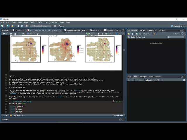
Learn how to estimate a geospatial risk predictive model in R. Using open data from San Francisco, we learn new tools for helping ...
5,013 views
TRANSFORM 2020 - Virtual Conference Speaker: Martin Bentley To access the repos link: https://swu.ng/t20-fri-geo Dedicated ...
3,712 views
Streamed 5 years ago
Upcoming Events Join our Meetup group for more events! https://www.meetup.com/data-umbrella Christy Heaton: Geospatial ...
2,145 views
3 years ago
Dataset: https://github.com/iamtekson/geospatial-data-analysis-python/raw/master/data/geotiff/nepal_lc_2020.tif Full course: ...
30,267 views
This is an introductory video to working with GeoPandas, using data pulled from Washing DC's Open Data page. We'll combine ...
22,970 views
In this video, we explore the powerful combination of Google Earth Engine and Python programming for advanced land cover ...
4,832 views
4 months ago
This tutorial video is about how to create geolocation maps from csv file by using Python and geopandas. Support me to make ...
3,080 views
2 years ago
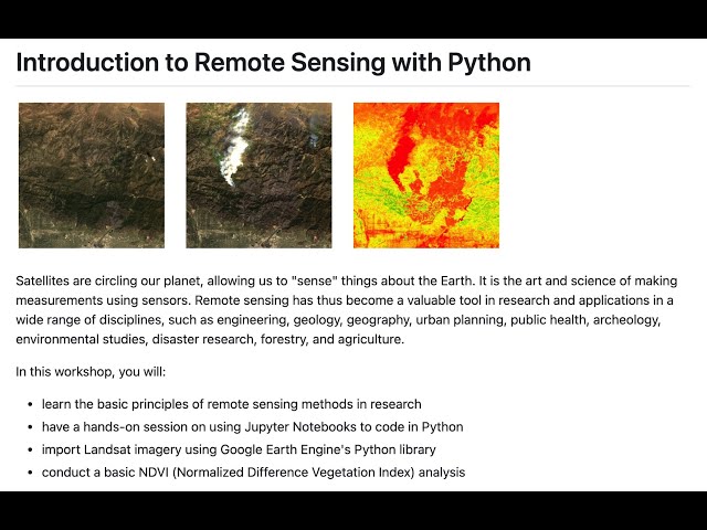
Instructor: Yoh Kawano Workshop materials: https://github.com/yohman/workshop-remote-sensing Satellites are circling our ...
20,470 views
This "Geospatial Analysis With Python" is a beginner's course for those who want to learn the use of python for gis and geospatial ...
42,895 views
Learn Python for geospatial data analysis using ArcGIS Pro Notebooks (built on Jupyter notebooks)—a practical, job-relevant ...
200 views
2 weeks ago
Ready to move beyond desktop GIS? Step into the Spatial Lab: a global community for ambitious geospatial professionals who ...
13,832 views
Download demo dataset: https://github.com/iamtekson/geospatial-data-analysis-python/tree/master/data/shp This video is the part ...
48,555 views
Learn more: https://spatialelearning.com Get the full course: ...
81,204 views
My invited talk on May 27, 2022. Slides: https://gishub.org/ussein Moderator: Dr. Labaly Toure at the University of Sine Saloum, ...
8,243 views
Workshop materials available here: https://github.com/yohman/workshop-python-spatial-stats Visual interpretations are ...
17,387 views
10,744 views
5,697 views
38,602 views
25,867 views


![[46] Geospatial Data and Maps with Python (Christy Heaton)](/api/proxy/image?url=https%3A%2F%2Fi.ytimg.com%2Fvi%2FEXHG-bLGT0Y%2Fsddefault.jpg)