Upload date
All time
Last hour
Today
This week
This month
This year
Type
All
Video
Channel
Playlist
Movie
Duration
Short (< 4 minutes)
Medium (4-20 minutes)
Long (> 20 minutes)
Sort by
Relevance
Rating
View count
Features
HD
Subtitles/CC
Creative Commons
3D
Live
4K
360°
VR180
HDR
135 results
Geospatial data processing has become increasingly important in modern GIS, location intelligence, urban planning, ...
0 views
3 days ago
Geospatial data visualization has become an essential component of modern data science, supporting applications in GIS, urban ...
1 view
Together, these components deliver a unified API for accessing and processing a wide variety of spatial data sources. Raster data ...
GeoAI is transforming how Earth observation data are analyzed and interpreted, yet its integration into geospatial education is ...
13 views
2 days ago
Ponente/Speaker: Álvaro Gutiérrez Climent Ponente/Speaker: Libertad Chapinal Cervantes -- El 29 de agosto de 2022 hubo una ...
10 views
7 days ago
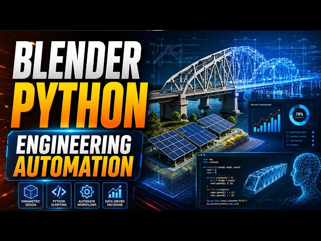
00:00 From Spreadsheets to Spatial Engineering 01:03 Blender as a Programmable Design Engine 02:09 Blender Python API: ...
32 views
1 day ago
One of the fastest-growing fields in GIS and Remote Sensing ✓ Combines AI with satellite imagery and spatial analysis ✓ High ...
496 views
Streamed 6 days ago
... field of artificial intelligence agents that require precise spatial analysis. https://spatialclaw.github.io/static/pdfs/spatialclaw.pdf.
56 views
00:00 Blender Beyond 3D Animation 01:47 Blender as a Software Engineering Platform 02:13 C++ Core, Python API ...
24 views
Keras segmentation models are often built locally, while the imagery lives in the cloud. This tutorial shows a clean way to bring the ...
27 views
Geoprocessing in the Browser: 700+ Free GIS Tools in GeoLibre, Zero Install GeoLibre v1.7.0 brings the full Whitebox Next Gen ...
2,785 views
Learn how to perform Cloud Native Remote Sensing with Python using modern geospatial technologies and cloud-based Earth ...
202 views
SpatialClaw is a new framework for improving 3D and 4D spatial reasoning in VLM-based agents. ▪️ Instead of relying only on ...
28 views
4 days ago
In this tutorial, My PhD student Mahmoud Elhadidy creates an idealized aneurysmal artery geometry in Ansys SpaceClaim.
35 views
... focuses on translating state-of-the-art geospatial AI research into practical workflows for remote sensing and spatial analysis.
131 views
Dive into the frequency domain! In this video, we build a complete Python script from scratch using NumPy, Matplotlib, and PIL to ...
5 days ago
In this introductory video, my PhD student Mahmoud Elhadidy presents the overall workflow covered in the next three tutorials.
22 views
Learn how to predict Future Land Use/Land Cover (LULC) changes using Cellular Automata (CA), Artificial Neural Networks ...
352 views
Streamed 3 days ago
We are excited to announce the release of DIANA, featuring numerous enhancements and updates to model definitions and ...
58 views
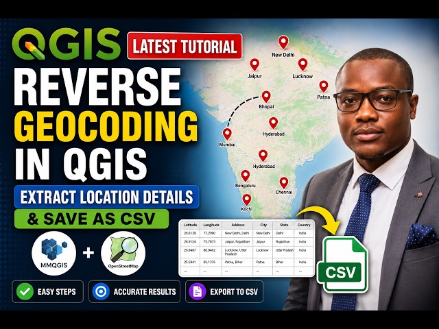
Learn how to perform **Reverse Geocoding in QGIS** using the **MMQGIS plugin** and **OpenStreetMap (OSM)** data.
34 views
23 hours ago