ViewTube

ViewTube
Sign inSign upSubscriptions
Filters

Upload date

Type

Duration

Sort by

Features

Reset

176,661 results

GIScience
#python #spatial #datascience #pyqgis

qgis #gis #opensource.

1:08
#python #spatial #datascience #pyqgis

2,349 views

8 months ago

Koyel Chakraborty
Spatial Data Analysis in GIS: Vector data analysis with Python- Day 1 #gis #geospatial #dataanalysis

This video is about spatial data analysis in GIS. Learn how to analyze vector data using python. Vector data model is a common ...

0:42
Spatial Data Analysis in GIS: Vector data analysis with Python- Day 1 #gis #geospatial #dataanalysis

2,913 views

7 months ago

Florent Poux
Top Geospatial Python Libraries and 3D Data Integration #python #geospatial #3d

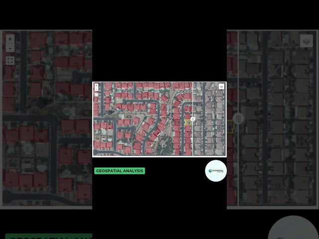
Processing geospatial data captured from sensors and vectors in a city or landscape is key. The article covers processes like ...

0:52
Top Geospatial Python Libraries and 3D Data Integration #python #geospatial #3d

1,796 views

1 year ago

GIScience
#python #spatial #datascience ArcPy

gis #arcgispro @RITCertified.

1:35
#python #spatial #datascience ArcPy

1,347 views

8 months ago

Matt Forrest
5 Python Libraries Every GIS Pro Needs to Know!

... you a GIS data science expert and greatly improve your geospatial skillset, allowing you to perform complex spatial analysis.

1:15
5 Python Libraries Every GIS Pro Needs to Know!

6,141 views

7 months ago

Matt Forrest
Geospatial Python - Full Course for Beginners with Geopandas

Learn GeoPandas and Modern GIS by joining the Spatial Lab ➡️ https://forrest.nyc/spatial-lab/ ⬅️ Looking to dive into ...

2:04:52
Geospatial Python - Full Course for Beginners with Geopandas

74,171 views

1 year ago

UCLA Office of Advanced Research Computing (OARC)
Introduction to Spatial Statistics with Python

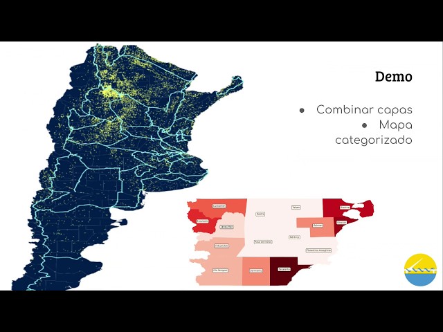
Workshop materials available here: https://github.com/yohman/workshop-python-spatial-stats Visual interpretations are ...

1:40:22
Introduction to Spatial Statistics with Python

17,360 views

4 years ago

famedancer713
Spatial Analysis in ArcGIS Pro #SpatialAnalysis #ArcGISPRO #DataAnalytics #Geospatial #DataScience
0:16
Spatial Analysis in ArcGIS Pro #SpatialAnalysis #ArcGISPRO #DataAnalytics #Geospatial #DataScience

63,462 views

3 years ago

Curiosity Data Analytics
Python Geospatial Viz Libraries | Folium, Leafmap, Pydeck & Kepler.gl

In this video, we compare four popular Python libraries for geospatial visualization: Folium, Leafmap, Pydeck, and Kepler.gl.

1:01
Python Geospatial Viz Libraries | Folium, Leafmap, Pydeck & Kepler.gl

1,682 views

1 year ago

Geospatial Analysis
GeoAI building detection using Python from Lidar. #geoai #googleearthengine #sam #pythongis
0:22
GeoAI building detection using Python from Lidar. #geoai #googleearthengine #sam #pythongis

1,382 views

7 months ago

Koyel Chakraborty
Spatial Data Analysis in GIS: Vector data analysis with Python- Day 2 #gis #geospatial #dataanalysis

This video is about spatial data analysis in GIS. Learn how to analyze vector data using python. Vector data model is a common ...

0:55
Spatial Data Analysis in GIS: Vector data analysis with Python- Day 2 #gis #geospatial #dataanalysis

363 views

6 months ago

LandSpace Architecture
How to extract GIS data with AI? #architecture #landscapearchitecture #map #urbandesign

How to extract GIS data online with AI check out this AI powered mapping tool simply type in your prompt and it will extract GIS ...

0:38
How to extract GIS data with AI? #architecture #landscapearchitecture #map #urbandesign

22,487 views

1 year ago

People also watched

PyAr - Python Argentina
Introducción a GIS con geopandas, por Leonardo Morales

La propuesta es que al finalizar la charla, el asistente tenga un vistazo general de dos aspectos: Los sistemas de información ...

27:03
Introducción a GIS con geopandas, por Leonardo Morales

7,574 views

7 years ago

Meteo Data
CODING Snippet 003: Spatial Analysis using Python Xarray & Cartopy| METEOROLOGY-RELATED Pep Talk

Welcome to METEOROLOGY-RELATED Pep Talk. This video focuses on generating spatial diagrams from multi-dimensional ...

16:35
CODING Snippet 003: Spatial Analysis using Python Xarray & Cartopy| METEOROLOGY-RELATED Pep Talk

6,046 views

5 years ago

Hertie School Data Science Lab
GeoData and Spatial Data Analysis with R | Data Science Summer School

Organized by the Hertie School Data Science Lab with the support of the SCRIPTS Cluster of Excellence and the Stifterverband, ...

4:14:51
GeoData and Spatial Data Analysis with R | Data Science Summer School

8,268 views

Streamed 4 years ago

PyCon JP
Geospatial data analysis and visualization in Python (Halfdan Rump) - PyCon JP 2017

... don't know um so I've shown you geopanners which is really sort of the basis of doing geospatial data analysis in Python and to ...

30:38
Geospatial data analysis and visualization in Python (Halfdan Rump) - PyCon JP 2017

19,718 views

Streamed 8 years ago

GeoDev
Rasterio for absolutely beginner | Geospatial data analysis with python | GeoDev

Dataset: https://github.com/iamtekson/geospatial-data-analysis-python/raw/master/data/geotiff/nepal_lc_2020.tif Full course: ...

27:11
Rasterio for absolutely beginner | Geospatial data analysis with python | GeoDev

30,173 views

4 years ago

BugBytes
Mapping with Python & Folium - Creating Maps from Raw CSV/JSON Data

Geospatial Python Playlist: https://www.youtube.com/playlist?list=PL-2EBeDYMIbRWlllfgcAJGkfUW0GFFrNu ☕ Buy a coffee: ...

14:12
Mapping with Python & Folium - Creating Maps from Raw CSV/JSON Data

31,897 views

3 years ago

Software Underground
Tutorial: Geospatial Analysis in Python

TRANSFORM 2020 - Virtual Conference Speaker: Martin Bentley To access the repos link: https://swu.ng/t20-fri-geo Dedicated ...

3:18:45
Tutorial: Geospatial Analysis in Python

3,710 views

Streamed 5 years ago

Geospatial Hut
Spatial weights, lag  and Spatial auto-correlation using Python

In this webinar, you will learn how to carry out Spatial weights, spatial lag and Spatial auto-correlation: in hotspot analysis in ...

1:06:39
Spatial weights, lag and Spatial auto-correlation using Python

2,743 views

4 years ago

GISWorld
Create Complex Maps in QGIS Easily with Deepseek AI! 🚀🗺️

deepseek #ai #qgis Want to create complex maps in QGIS effortlessly? With Deepseek AI, you can generate detailed and ...

8:42
Create Complex Maps in QGIS Easily with Deepseek AI! 🚀🗺️

10,718 views

1 year ago

UCLA Office of Advanced Research Computing (OARC)
Introduction to Remote Sensing with Python

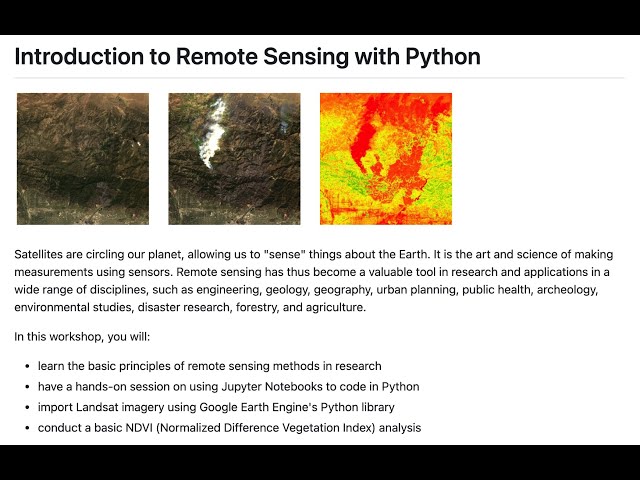
Instructor: Yoh Kawano Workshop materials: https://github.com/yohman/workshop-remote-sensing Satellites are circling our ...

1:04:39
Introduction to Remote Sensing with Python

20,417 views

4 years ago

Matt Forrest
Visualize geographic data in Python!

Ready to move beyond desktop GIS? Step into the Spatial Lab: a global community for ambitious geospatial professionals who ...

3:25
Visualize geographic data in Python!

13,744 views

1 year ago

Matt Forrest
What Is Spatial Data? A Beginner’s Guide

Ready to move beyond desktop GIS? Step into the Spatial Lab: a global community for ambitious geospatial professionals who ...

8:28
What Is Spatial Data? A Beginner’s Guide

14,323 views

11 months ago

Earth Science
Introduction to Spatial Data Analysis with Python

Introduction to Spatial Data Analysis with Python #Map-Projection and #CoordinateSystems in #ArcGIS A Complete QGIS Tutorial ...

37:06
Introduction to Spatial Data Analysis with Python

3,689 views

4 years ago