ViewTube

ViewTube
Sign inSign upSubscriptions
Filters

Upload date

Type

Duration

Sort by

Features

Reset

85 results

Data Science with Onur
Data Visualization with Python Course [2026] - Part 3: Categorical, Statistical & Geospatial Charts

In Part 3 of this Data Visualization with Python Course 2026, you will create categorical, advanced statistical, and geospatial ...

16:25
Data Visualization with Python Course [2026] - Part 3: Categorical, Statistical & Geospatial Charts

70 views

6 days ago

School of Programming and Software Development
Exploratory Data Analysis  - Python (Week 7 - Lesson 1)

School of Programming and Software Development sop-AI-101: Python for Data Science This lesson introduces us to Exploratory ...

5:15
Exploratory Data Analysis - Python (Week 7 - Lesson 1)

14 views

6 days ago

casaGeo
Streamline Geo Data Science: HERE Connector for Python

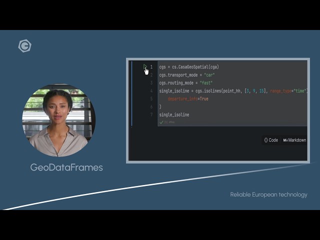
Get your Geo Data Science projects moving faster with the HERE Connector for Python by casaGeoTools. In this video, we show ...

1:09
Streamline Geo Data Science: HERE Connector for Python

0 views

5 hours ago

Final Draft Mapping
Adding Point Features to an ArcGIS Online Feature Layer with the ArcGIS API for Python

Full Course https://www.youtube.com/playlist?list=PLWlgkWEhTvz0oqrq6PP6ZbkMqCLXXMNsT Learn how to *add point ...

4:20
Adding Point Features to an ArcGIS Online Feature Layer with the ArcGIS API for Python

17 views

5 days ago

GeoForger
Mapryx AI Assistant Demo

“Calculate coverage area of point layer” → Quick spatial analysis without manual geoprocessing steps. 4. “Calculate average ...

3:58
Mapryx AI Assistant Demo

8 views

4 days ago

Geomatica Ambiental
🚀🌎 Course Summary: Geographic Information Systems with Python🐍🗺️

Do you want to become a GIS expert with Python and automate professional geospatial processes? This course will take you from ...

6:42
🚀🌎 Course Summary: Geographic Information Systems with Python🐍🗺️

33 views

2 days ago

Native GIS
Spatial AI Scientist: Skills & Career Path Revealed

Spatial AI Scientist is redefining how artificial intelligence works with geography, spatial data, and real-world systems. In this video ...

4:50
Spatial AI Scientist: Skills & Career Path Revealed

98 views

7 days ago

GeoForger
Introducing Mapryx Ai Assistant

Spatial Analysis: "Calculate the total area of parks in this district" or "Find all bus stops within 500m of the metro station.

0:49
Introducing Mapryx Ai Assistant

0 views

4 days ago

Terra Spatial
Calculate Monthly Total Suspended Matter (TSM) Using Sentinel-2A Image | GEE Python Colab

In this complete scientific workflow, you'll learn how to calculate Monthly Total Suspended Matter (TSM) using Google Earth ...

49:29
Calculate Monthly Total Suspended Matter (TSM) Using Sentinel-2A Image | GEE Python Colab

187 views

2 days ago

Final Draft Mapping
Adding Polyline Features to an ArcGIS Online Feature Layer with the ArcGIS API for Python

Full Course https://www.youtube.com/playlist?list=PLWlgkWEhTvz0oqrq6PP6ZbkMqCLXXMNsT Learn how to *add polyline ...

4:58
Adding Polyline Features to an ArcGIS Online Feature Layer with the ArcGIS API for Python

8 views

5 days ago

David Arnold Jr
Predictive Modeling for Urban Heat Islands assignment- week 3
2:31
Predictive Modeling for Urban Heat Islands assignment- week 3

0 views

6 days ago

Yo4GIS Solutions
Power Of GeoPy

GEOPY.

2:05:58
Power Of GeoPy

81 views

3 days ago

SUNY Librarians Association TDG
Session 7: Data-Driven Space Planning: Using Python to Analyze Collection Growth Through LC Class..

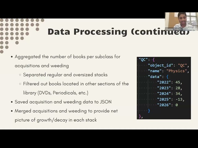
by Corinne Chatnik and Mukundan Thanigaivelan (Union College) As library collections evolve, understanding spatial growth ...

31:06
Session 7: Data-Driven Space Planning: Using Python to Analyze Collection Growth Through LC Class..

0 views

5 days ago

GIS Developer
QGIS + PostgreSQL Tutorial | Connect Database & Load Spatial Data Easily

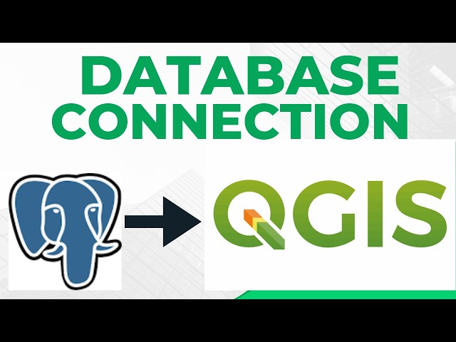
referralCode=94E14087067E7BE7C648 In this tutorial, I show you how to connect PostgreSQL to QGIS and load spatial data ...

6:12
QGIS + PostgreSQL Tutorial | Connect Database & Load Spatial Data Easily

11 views

1 day ago

Open Geospatial Solutions
How to Visualize LiDAR Point Clouds From NOAA Digital Coast (Step-by-Step)

... https://amazon.com/dp/B0FFW34LL3 Leanpub: https://leanpub.com/gispro Spatial Data Management with DuckDB: From ...

17:36
How to Visualize LiDAR Point Clouds From NOAA Digital Coast (Step-by-Step)

570 views

6 days ago

Esri Developers
ArcGIS and GeoAI: Using Large Language Models and Foundation Models | #EsriDevSummit2025

Large language models (LLMs) and foundation models are revolutionizing GeoAI as they need little or no fine-tuning. Join us to ...

56:08
ArcGIS and GeoAI: Using Large Language Models and Foundation Models | #EsriDevSummit2025

78 views

18 hours ago

GeoTechDev
QGIS 2025: Cours 5 - Jointure et densité de population
1:45:41
QGIS 2025: Cours 5 - Jointure et densité de population

100 views

9 days ago

Final Draft Mapping
Updating an ArcGIS Online WebMap Extent Based from a Polygon with the ArcGIS API for Python

WebMap Layer Index https://youtu.be/fDF4Ctg7RxQ Blog post ...

5:46
Updating an ArcGIS Online WebMap Extent Based from a Polygon with the ArcGIS API for Python

36 views

2 days ago

GeoTechDev
QGIS 2025: Lesson 6 - Final Population and Density Map

My WhatsApp channel: https://whatsapp.com/channel/0029VakCEuE3GJOz0vr4Nr16/133 Want to learn? ⬇️I've launched my new ...

47:20
QGIS 2025: Lesson 6 - Final Population and Density Map

39 views

1 day ago

Monesh Venkul
59  Unleashing an Avengers-Level Multimodal AI Project!

59 - Unleashing an Avengers-Level Multimodal AI Project! In this video: Dive into the fascinating world of multimodal projects with ...

26:44
59 Unleashing an Avengers-Level Multimodal AI Project!

3 views

7 days ago