ViewTube

ViewTube
Sign inSign upSubscriptions
Filters

Upload date

Type

Duration

Sort by

Features

Reset

85 results

Matt Forrest
Mastering Spatial Data in R: TidyCensus, PMTiles, & AI with Kyle Walker

... Data is Critical Infrastructure 00:09:20 – Demystifying Census Data with tigris and tidycensus 00:15:48 – Applied Spatial Data: ...

50:31
Mastering Spatial Data in R: TidyCensus, PMTiles, & AI with Kyle Walker

1,104 views

6 days ago

casaGeo
Getting Started - HERE Connector for Python (casaGeoTools)

Master spatial data in Python! In this 60-second quickstart, Taisin shows you how to install casaGeoTools, set up secure ...

1:01
Getting Started - HERE Connector for Python (casaGeoTools)

6 views

7 days ago

Geomatica Ambiental
🚀🌎 𝗥𝗲𝘀𝘂𝗺𝗲𝗻 𝗖𝘂𝗿𝘀𝗼: 𝗦𝗶𝘀𝘁𝗲𝗺𝗮𝘀 𝗱𝗲 𝗜𝗻𝗳𝗼𝗿𝗺𝗮𝗰𝗶𝗼́𝗻 𝗚𝗲𝗼𝗴𝗿𝗮́𝗳𝗶𝗰𝗮 𝗰𝗼𝗻 𝗣𝘆𝘁𝗵𝗼𝗻🐍🗺️

Quieres convertirte en experto en SIG con Python y automatizar procesos geoespaciales profesionales? Este curso te llevará ...

6:42
🚀🌎 𝗥𝗲𝘀𝘂𝗺𝗲𝗻 𝗖𝘂𝗿𝘀𝗼: 𝗦𝗶𝘀𝘁𝗲𝗺𝗮𝘀 𝗱𝗲 𝗜𝗻𝗳𝗼𝗿𝗺𝗮𝗰𝗶𝗼́𝗻 𝗚𝗲𝗼𝗴𝗿𝗮́𝗳𝗶𝗰𝗮 𝗰𝗼𝗻 𝗣𝘆𝘁𝗵𝗼𝗻🐍🗺️

23 views

21 hours ago

TechnicallyRipped
Write Better Matplotlib Code with This Small Change | Python Tutorial

Assigning your plt.plot call to a variable lets you directly control the line after it's drawn. Change colors, styles, widths, and add ...

0:46
Write Better Matplotlib Code with This Small Change | Python Tutorial

226 views

4 hours ago

CV orbit
🚀YOLOv8 Object Tracking in Python using OpenCV! #computervision #automobile #deeplearning #education

YOLOv8 Object Tracking in Python using OpenCV! Track multiple objects in real time with unique IDs using YOLOv8 and the ...

0:32
🚀YOLOv8 Object Tracking in Python using OpenCV! #computervision #automobile #deeplearning #education

0 views

5 hours ago

CW-zone
Visual Art & Style with Python 💻✨#viralreels #codingshorts #satiafying #pythonvisualization #fps
0:15
Visual Art & Style with Python 💻✨#viralreels #codingshorts #satiafying #pythonvisualization #fps

0 views

3 hours ago

GeoForger
Introducing Mapryx Ai Assistant

Spatial Analysis: "Calculate the total area of parks in this district" or "Find all bus stops within 500m of the metro station.

0:49
Introducing Mapryx Ai Assistant

0 views

3 days ago

Data Science with Onur
Data Visualization with Python Course [2026] - Part 3: Categorical, Statistical & Geospatial Charts

In Part 3 of this Data Visualization with Python Course 2026, you will create categorical, advanced statistical, and geospatial ...

16:25
Data Visualization with Python Course [2026] - Part 3: Categorical, Statistical & Geospatial Charts

68 views

5 days ago

Terra Spatial
Calculate Monthly Total Suspended Matter (TSM) Using Sentinel-2A Image | GEE Python Colab

In this complete scientific workflow, you'll learn how to calculate Monthly Total Suspended Matter (TSM) using Google Earth ...

49:29
Calculate Monthly Total Suspended Matter (TSM) Using Sentinel-2A Image | GEE Python Colab

95 views

9 hours ago

School of Programming and Software Development
Exploratory Data Analysis  - Python (Week 7 - Lesson 1)

School of Programming and Software Development sop-AI-101: Python for Data Science This lesson introduces us to Exploratory ...

5:15
Exploratory Data Analysis - Python (Week 7 - Lesson 1)

12 views

4 days ago

Final Draft Mapping
Adding Polyline Features to an ArcGIS Online Feature Layer with the ArcGIS API for Python

Full Course https://www.youtube.com/playlist?list=PLWlgkWEhTvz0oqrq6PP6ZbkMqCLXXMNsT Learn how to *add polyline ...

4:58
Adding Polyline Features to an ArcGIS Online Feature Layer with the ArcGIS API for Python

5 views

3 days ago

GeoForger
Mapryx AI Assistant Demo

“Calculate coverage area of point layer” → Quick spatial analysis without manual geoprocessing steps. 4. “Calculate average ...

3:58
Mapryx AI Assistant Demo

7 views

3 days ago

Final Draft Mapping
Adding Point Features to an ArcGIS Online Feature Layer with the ArcGIS API for Python

Full Course https://www.youtube.com/playlist?list=PLWlgkWEhTvz0oqrq6PP6ZbkMqCLXXMNsT Learn how to *add point ...

4:20
Adding Point Features to an ArcGIS Online Feature Layer with the ArcGIS API for Python

11 views

3 days ago

Native GIS
Spatial AI Scientist: Skills & Career Path Revealed

Spatial AI Scientist is redefining how artificial intelligence works with geography, spatial data, and real-world systems. In this video ...

4:50
Spatial AI Scientist: Skills & Career Path Revealed

72 views

5 days ago

SUNY Librarians Association TDG
Session 7: Data-Driven Space Planning: Using Python to Analyze Collection Growth Through LC Class..

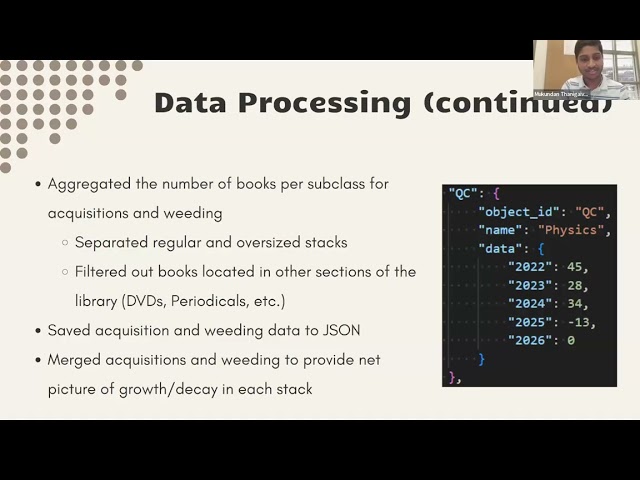
by Corinne Chatnik and Mukundan Thanigaivelan (Union College) As library collections evolve, understanding spatial growth ...

31:06
Session 7: Data-Driven Space Planning: Using Python to Analyze Collection Growth Through LC Class..

0 views

4 days ago

GIS Developer
QGIS + PostgreSQL Tutorial | Connect Database & Load Spatial Data Easily

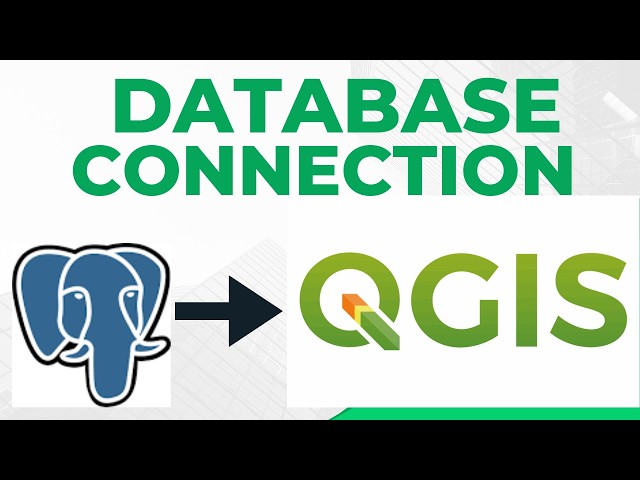
referralCode=94E14087067E7BE7C648 In this tutorial, I show you how to connect PostgreSQL to QGIS and load spatial data ...

6:12
QGIS + PostgreSQL Tutorial | Connect Database & Load Spatial Data Easily

0 views

9 minutes ago

Labellerr AI
Build an ADAS System: Lane Detection & Mapping withYOLO | Autonomous Driving AI

In this video, I showcase my latest computer vision project: Advanced Vision-Based ADAS with Real-Time Schematic Mapping.

13:06
Build an ADAS System: Lane Detection & Mapping withYOLO | Autonomous Driving AI

119 views

7 days ago

IIRS ISRO Digital Learning Programme
Image Intensity Transformation & Spatial Filtering using GDAL & Opencv by Ravi Bhandari

IIRS-ISRO.

1:14:08
Image Intensity Transformation & Spatial Filtering using GDAL & Opencv by Ravi Bhandari

2,699 views

Streamed 6 days ago

Yann Tourman
R-Weekly Podcast: Issue 2023-W39 Highlights - E138

... the Nix reproducible data science train powers forward into CI/CD territory, and leveraging parallel processing in spatial data ...

39:22
R-Weekly Podcast: Issue 2023-W39 Highlights - E138

0 views

7 days ago

Open Geospatial Solutions
How to Visualize LiDAR Point Clouds From NOAA Digital Coast (Step-by-Step)

... https://amazon.com/dp/B0FFW34LL3 Leanpub: https://leanpub.com/gispro Spatial Data Management with DuckDB: From ...

17:36
How to Visualize LiDAR Point Clouds From NOAA Digital Coast (Step-by-Step)

510 views

5 days ago