Upload date
All time
Last hour
Today
This week
This month
This year
Type
All
Video
Channel
Playlist
Movie
Duration
Short (< 4 minutes)
Medium (4-20 minutes)
Long (> 20 minutes)
Sort by
Relevance
Rating
View count
Features
HD
Subtitles/CC
Creative Commons
3D
Live
4K
360°
VR180
HDR
144 results
Jess Hoffelder and Ganhua Lu, University of Wisconsin Madison Population Health Institute Access to exercise opportunities is a ...
76 views
2 years ago
This video is an introduction to vector data and how to work with it in R. Vector data includes all kinds of spatial data that are not ...
6,747 views
5 years ago
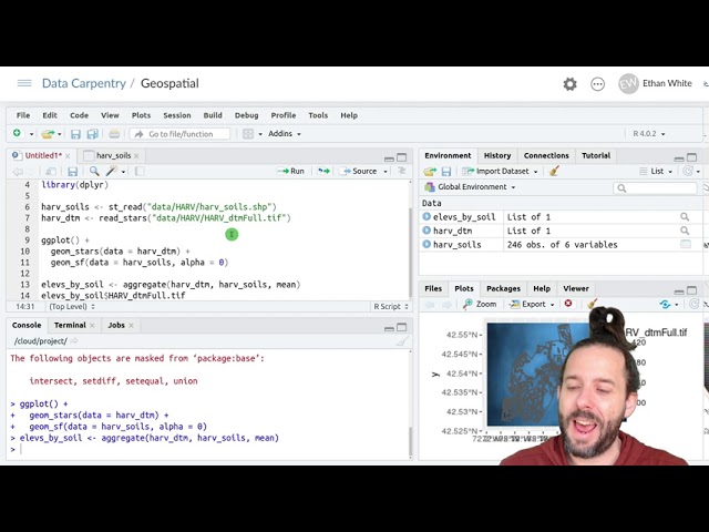
And if we run that line we'll see that we get out the seven elevations one matched to each row in the 'plots_harv_utm' spatial data ...
12,168 views
Data: https://datacarpentry.org/semester-biology/data/neon-geospatial-data.zip Written notes: ...
5,025 views
This video is about how to save spatial data that we've created in R and write it out to the kinds of files that we've been loading in.
2,521 views
Speaker: Wendi Bacon Captions: Wendi Bacon.
251 views
Data: https://datacarpentry.org/semester-biology/data/neon-geospatial-data.zip Full lessons (including multiple videos and ...
27,166 views
Week 6: Tutorial 05 Part 02: Speckle Filtering Using Python Using Gaussian Filter.
795 views
4 years ago
This video is part of MANTRA, the Research Data Management free online course created by the University of Edinburgh Data ...
5,323 views
12 years ago
Get insights from Ed Parsons, Geospatial Technologist at google on: Why SDIs are not working like they are meant to be!
1,603 views
11 years ago
This video Introduces the Jefferson Community and Technical College, GIS Data Analysis class (CIT 225). In this video Professor ...
191 views
9 years ago
This video is about making plots that maintain the units of the projection that we're working with using spatial data in ggplot.
2,056 views
Presenter: Martin Westgate Session: Automation (text analysis) (https://youtu.be/upMLe6_khDk) Title: An introduction to revtools ...
1,112 views
Site du cours ECL8202: Analyses des données complexes à l'Université du Québec en Abitibi-Témiscamingue: ...
1,339 views
6 years ago
This video is part of 'Water Productivity and Water Accounting using WaPOR' Open Courseware, IHE Delft OpenCourseWare Join ...
3,651 views
Presentation at Pedometrics 2015. The original paper is at: http://dx.doi.org/10.1016/j.spasta.2015.04.001.
1,213 views
10 years ago
A short introduction to the core concepts on single-cell omics data and spatial omics data. I will start by introducing how these ...
13,019 views
3 years ago
This video is part of the virtual useR! 2020 conference. Find supplementary material on our website https://user2020.r-project.org/.
2,094 views
The GIS app allows you to do thematic mapping of areas and points, view facilities based on classifications, and visualize ...
6,529 views
7 years ago
... file so um there's various places you could get them um on the city of madison website for example they have this data portal up ...
379 views


![[WAPOROCW] M1-3.3 Spatial data analysis using QGIS](/api/proxy/image?url=https%3A%2F%2Fi.ytimg.com%2Fvi%2FRovF2OAq15o%2Fsddefault.jpg)


