Upload date
All time
Last hour
Today
This week
This month
This year
Type
All
Video
Channel
Playlist
Movie
Duration
Short (< 4 minutes)
Medium (4-20 minutes)
Long (> 20 minutes)
Sort by
Relevance
Rating
View count
Features
HD
Subtitles/CC
Creative Commons
3D
Live
4K
360°
VR180
HDR
486 results
We advance geospatial data science through providing optimal dev ops for anyone to build geospatial models in a GDAL native ...
60 views
1 year ago
Finnegan Pope-Carter GSB (SUMO) & University of Bradford Geophysical data collection is increasingly moving from Grid based ...
970 views
10 years ago
We introduce the python shapely library for manipulating polygons.
1,214 views
3 years ago
Get an overview of open-source Python packages and libraries for handling geospatial data based on explanations from ...
109 views
Dr. Francesco Nattino (eScience Center) introduces the Clustering Geo-Data Cubes (CGC) package, which focuses on the needs ...
303 views
Dr. Francesco Nattino (Research Software Engineer, eScience Center) introduces the data carpentry course they have developed ...
52 views
Session Outline: Defining Spatial Data and GIS Data Collection Methods for GIS Analysis Techniques in GIS Case Studies: ...
1,540 views
Hi my name is holger and today i'll um introduce you to some of the useful geospatial libraries for data analysis in python and we'll ...
70 views
4 years ago
This video is part of the open course Programming for Geospatial Hydrological Applications. In this course you'll learn an ...
1,514 views
1,500 views
telluric: interactive manipulation of Geospatial data with Jupyter and Python telluric library is an open source library developed by ...
272 views
7 years ago
GIS software is used to analyze spatial data. In some cases, GIS data can be voluminous and Python can come in handy. Such a ...
55 views
5 years ago
My arcgis folder press right click new python file i'll rename mine arc gis. Let's import arc gis library if you don't already have ...
267 views
Convert Raster to CSV and plot as points on the grid using Python I hope you found a solution that worked for you :) The Content ...
17 views
http://acolita.com See how you can take full advantage of #ChatGPT to program in any programming language. In this case, we ...
13,662 views
We imported building footprints from OpenStreetMap, calculated their geometric center, and then showed buildings that are within ...
308 views
1,108 views
hello there, in this lesson, we will use geopandas and matplotlib to plot a geographic map from a CSV file with longitude and ...
64,463 views
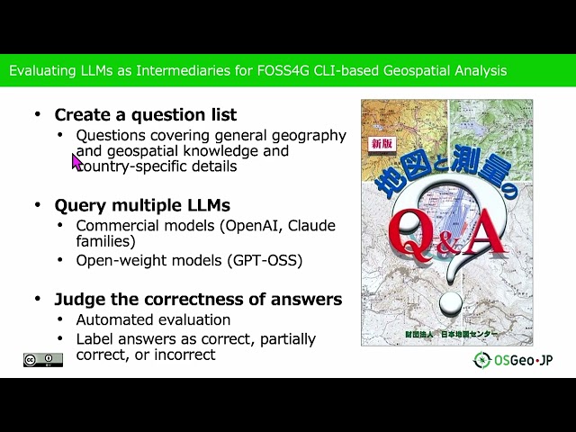
Presented by Nobusuke Iwasaki, Ayaka Onohara on 20 November 2025 09:05, at FOSS4G 2025 Auckland. Track: Lightning talk ...
2 months ago
Block H of the Geographic Data Science course - "Points" More materials related to the content in this video are available at: ...
406 views