Upload date
All time
Last hour
Today
This week
This month
This year
Type
All
Video
Channel
Playlist
Movie
Duration
Short (< 4 minutes)
Medium (4-20 minutes)
Long (> 20 minutes)
Sort by
Relevance
Rating
View count
Features
HD
Subtitles/CC
Creative Commons
3D
Live
4K
360°
VR180
HDR
6,980 results
Learn how to use of Python for gis and geospatial analysis. This course will cover the basics of geopandas for beginners for ...
559 views
3 years ago
This workshop is ideal for someone who has recently started using python and exploring the possibilities of it in the GIS industry.
1,445 views
4 years ago
In this comprehensive GIS tutorial, we'll move beyond basic mapping to answer a critical urban planning question: How ...
2,874 views
1 year ago
Get an overview of open-source Python packages and libraries for handling geospatial data based on explanations from ...
117 views
... don't know um so I've shown you geopanners which is really sort of the basis of doing geospatial data analysis in Python and to ...
19,725 views
Streamed 8 years ago
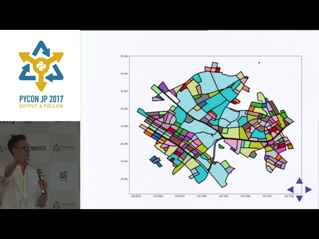
by Joris Van den Bossche At: FOSDEM 2018 Room: AW1.126 Scheduled start: 2018-02-04 11:30:00+01.
6,336 views
8 years ago
TRANSFORM 2020 - Virtual Conference Speaker: Martin Bentley To access the repos link: https://swu.ng/t20-fri-geo Dedicated ...
3,791 views
Streamed 6 years ago
"Geospatial Analysis using Python and JupyterHub [EuroPython 2019 - Talk - 2019-07-10 - Singapore [PyData track] [Basel, CH] ...
6 years ago
Dr. Francesco Nattino (Research Software Engineer, eScience Center) introduces the data carpentry course they have developed ...
53 views
Processing Geodata using Python and Open Source Modules [EuroPython 2018 - Talk - 2018-07-27 - PyCharm [PyData]] ...
3,072 views
7 years ago
Dr. Francesco Nattino (eScience Center) introduces the Clustering Geo-Data Cubes (CGC) package, which focuses on the needs ...
307 views
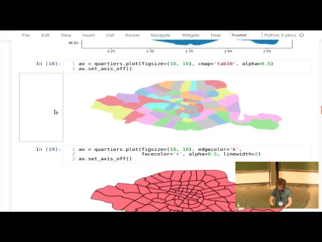
Presenter: Joris Van den Bossche.
12,415 views
Hi my name is holger and today i'll um introduce you to some of the useful geospatial libraries for data analysis in python and we'll ...
71 views
We advance geospatial data science through providing optimal dev ops for anyone to build geospatial models in a GDAL native ...
69 views
Talk #1: Geospatial Analysis & Visualisation This talk gives a basic introduction to geospatial analysis and visualisation, and how ...
136 views
lecture by B. Rowlingson http://www.geostat-course.org/Bergen_2014.
878 views
11 years ago
Convert Raster to CSV and plot as points on the grid using Python I hope you found a solution that worked for you :) The Content ...
18 views
The IPython Notebooks (now Jupyter Notebooks) and instructions how to use them are available at: ...
9,010 views
10 years ago
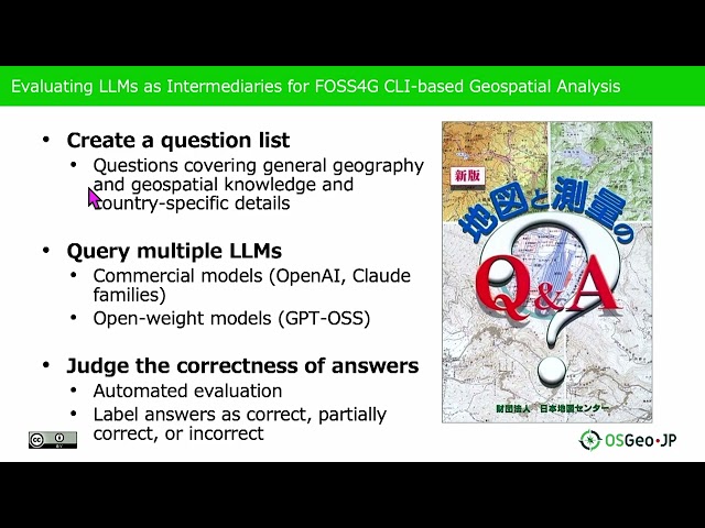
Presented by Nobusuke Iwasaki, Ayaka Onohara on 20 November 2025 09:05, at FOSS4G 2025 Auckland. Track: Lightning talk ...
76 views
6 months ago
https://amzn.to/4aLHbLD You're literally one click away from a better setup — grab it now! As an Amazon Associate I earn ...
168 views